Case study: The sale of Waipoua–Maunganui
Crown agents took advantage of a dispute which two chiefs, Tiopira and Parore, had over the ownership of the Waipoua-Maunganui block. During the survey, the Crown partitioned the land into two separate blocks. The chiefs then agreed between themselves that the Maunganui block should belong to Tiopira and Waipoua should belong to Parore. The area known as Waipoua 2 would be a native reserve belonging to Tiopira. The Native Land Court made this agreement official, and named 10 owners, including both chiefs, for each block. The Crown land purchase agent then dealt with each of the owners separately. First, he got Tiopira to sign the deeds of sale before the purchase price had been written in. Then, by offering a higher price, he persuaded the reluctant Parore to sell, and wrote the higher price into the deed. He paid Parore tamana of £500 to persuade him to sell, and also granted him a reserve, a 250-acre eel fishery at Lake Taharoa on the Maunganui block.
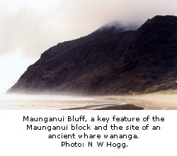
The Crown was in a hurry and failed to survey the land properly before the sale went through the Native Land Court. The chiefs had a spoken agreement with the purchase agents that certain wahi tapu on the Maunganui block would not be sold but would be kept as native reserves. However, when they surveyed that block, the European surveyors drew straight lines across the map instead of using traditional boundary markers such as landmarks and rivers, and some of the intended reserves were bypassed by the lines.
Two reserves, Manuwhetai and Whangaiariki, were specially surveyed on a separate plan. But this survey did not become part of the plan which was attached to the deed of sale. That is how Manuwhetai and Whangaiariki became part of the land sold. Maun-ganui Bluff was sold simply because it had not been surveyed, so it did not appear as a reserve on the plan. Te Roroa did not realise that their wahi tapu had been sold until some years later, when the Crown subdivided the land and resold it.
The accompanying map [GIF, 155 KB] shows the areas which were intended to be reserved and how much land was actually reserved.
This page was last updated: